At Dart Harbour we are committed to play out part to help achieve a good quality of water in the estuary, both for our customers, and for the huge variety of wildlife that make it their home. Water quality in the estuary and the catchment area is regularly monitored by the Environment Agency (EA), and this page is to help you find and understand this information, and to help you play your part to improve the standard of water in the river.
South West Water are currently undergoing a major project to improve the quality of water on the river –
Bathing Water Quality
In the Dart we have designated bathing water sites at Castle and Sugary Cove, Warfleet Creek, Dittisham, Stoke Gabriel and Steamer Quay Totnes. The EA monitor the water quality here every week from May to September, as well as checking for visible pollution. Between these sites which are well spaced along the river, the whole estuary is well monitored – probably the best monitored river in the UK, which means that wild swimmers and those taking part in other ‘wet’ watersports can understand the risks involved in entering the water.
The Castle & Sugary Cove site has been monitored for many years, and the water quality has been assessed as excellent on an annual basis. The other sites are newly designated for 2024, so do not have historic information, however the weekly sample data can be found on the above links. As well as sampling during the summer, alerts are issued year-round for potential pollution events. We will provide this information via our facebook page, or via Local Notices to Mariners for more significant events.
Southwest Water now provide live data of discharges that may impact the water quality at these beaches on their WaterFit Live page.
There are a number of untreated waste water outflows onto the river, and these are more likely to operate following heavy rain, when water flowing down drains overwhelms the capacity of the sewage treatment plants. South West Water have invested millions of pounds in improving the waste water infrastructure on the Dart, and are continuing to upgrade the infrastructure to reduce these outflows. Waste water discharge points are shown in detail on this map
Water Quality and the Environment
The EA regularly monitors the condition of the water on the Dart, looking at amount of wildlife (fish, plants, invertibrates and microorganisms), amount of oxygen and nutrients in the water, and the amount of pollutants and chemicals. There is monthly monitoring at 5 sites on the estuary, and detailed surveys are done every few years of the entire estuary and its catchment area.
The detailed survey for the Dart Estuary is located here Catchment Explorer. You may also be interested in the equivalent surveys for the 23 different fresh water tributaries that run into the Estuary here. The raw data from all of the survey points on the Dart and surrounding waters can be found on Open WIMS
In the most recent (2019) detailed survey, the Dart Estuary was classified as ‘Moderate’ for ecological matters and ‘Fail’ for chemical matters. Whilst these results sound bad, it is important to put them in context. In 2019 almost every river in the UK was classified as ‘Fail’ for chemicals, because Polybrominated diphenyl ethers (PBDE) were added to the testing regime. These chemicals are used as fire retardants, and whilst their use is now restricted, they decay and disperse very slowly, and with no practical way to remove them from the environment, they will sadly be with us for a considerable amount of time. The Dart also failed for the level of mercury in the water. This is common with many rivers in the South West, and is mainly as a result of historic mining in the industrial revolution – again this chemical remains in the system for a very long time. The Dart was rated as ‘Good’ or ‘High’ for all other chemicals, it is important to note here that ‘high’ means a high quality of water, not a high level of chemicals!
For Ecological matters, the story is also mixed. Sadly the levels of fish and angiosperms (flowering plants) has reduced in recent years. For fish, this is driven by low numbers of Salmon. Studies on the Tamar indicate that the issue here is at sea – the fish are not surviving to return to the rivers to breed. The South Devon Area of Outstanding Natural Beauty (AONB) team are working on saltmarsh projects to help restore the flowering plants levels, which Dart Harbour will continue to support.
The dissolved inorganic nitrogen level in the estuary is classified as Moderate. This is principally due to farming practices – livestock, soil and nutrient management, as well as waste water discharges, though leisure boating does play its part as well. South West Water are working hard to reduce these discharges, and many local farmers are also improving their ways of working.
Water flow into the river is highly dependent on rainfall into the catchment area. The monthly Devon and Cornwall report on this environment agency link contains full details about the rainfall, fresh water flow rate, and groundwater levels.
How can I help
It may seem like one family can make little difference to the water quality on the Dart, given the massive 48,000 hectare catchment area for the river. However we can all play our part, and simple actions make a big difference. Examples include:
- Avoid using sea toilets on the river. Use facilities ashore, or fit your boat with a holding tank. Pump out facilities are available at Darthaven Marina.
- Never throw any rubbish into the river, even small things like cigarette ends.
- Keep your boat’s bilges clean. Never allow any oil to spill into the river.
- Take part in litter collection from the river – Dart Harbour provides waste bins, and can help dispose of larger quantities of waste from the river.
- Be careful what you put down your sink, toilet and drain. Food waste, oil and wet wipes, even in small quantities can significantly reduce the ability of the local sewage treatment plants to do their job efficiently
- Don’t pave your garden. Where rainwater can soak away, it won’t contribute to overloading the waste water system
- Encourage farmers to adopt best practices, by buying organic or red tractor marked produce.
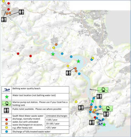
Key Locations
The below map shows locations of discharges of treated waste water, as well as locations of storm sewer overflows with an indication of how often they spilled untreated waste water into the estuary. It also gives locations of testing sites, public toilets, and pump out facilities
2022 discharges
The following locations had the greatest duration of discharges during the 2022 calendar year in the Dart Catchment area. This data comes from https://environment.data.gov.uk/portalstg/home/item.html?id=2f8d9b7628dd4f60a30fb1a8483fc2ae
Note that media reported that Warfleet Creek station has more spills than any other location in the country. The number of spills is high (364), but the duration is relatively low – 645 hours during 2022. This corresponds to an average of just under two hours per day.
| Site Name | Total Duration (hrs) all spills during year | Number of spills |
| HARBERTONFORD WASTEWATER TREATMENT WORKS | 2141.50 | 102 |
| HARBERTON WASTEWATER TREATMENT WORKS | 2136.50 | 129 |
| RATTERY WASTEWATER TREATMENT WORKS COMBINED SEWER OUTFALL | 1955.52 | 140 |
| HARBERTON WASTEWATER TREATMENT WORKS | 1883.40 | 131 |
| CORNWORTHY SEWAGETREATMENT WORKS | 1446.39 | 104 |
| TOTNES SEWAGETREATMENT WORKS | 1334.63 | 70 |
| HOLNE WASTEWATER TREATMENT WORKS | 1320.34 | 124 |
| BUCKFASTLEIGH SEWAGETREATMENT WORKS | 1089.16 | 82 |
| BROADHEMPSTON WASTEWATER TREATMENT WORKS COMBINED SEWER OUTFALL | 1049.59 | 113 |
| SCORRITON SEWAGETREATMENT WORKS | 890.57 | 107 |
| BUCKFASTLEIGH SEWAGETREATMENT WORKS | 649.65 | 103 |
| WARFLEET CREEK PUMPING STATION | 644.77 | 364 |
| DARTINGTON B COMBINED SEWER OUTFALL | 478.45 | 50 |
| STOKE GABRIEL SCOUT HUT COMBINED SEWER OUTFALL | 353.67 | 39 |
| DITTISHAM WASTEWATER TREATMENT WORKS | 350.22 | 54 |
| DARTINGTON C COMBINED SEWER OUTFALL | 321.17 | 42 |
| IPPLEPEN WASTEWATER TREATMENT WORKS | 294.50 | 22 |